Direct attack on Sichuan Luding M6.8 earthquake rescue: Race against time, these high technologies save more lives.
The communication between Moxi Town and Yanzigou Town in the epicenter was interrupted, and landslides and houses in Detuo Town were seriously damaged. Roads in Lengzhai Town were interrupted, and some villages were interrupted by communication and roads.……
"Island", "Island" and "Island" …
With one by oneWith the continuous emergence of "isolated islands", it is urgent to quickly restore the "three faults".
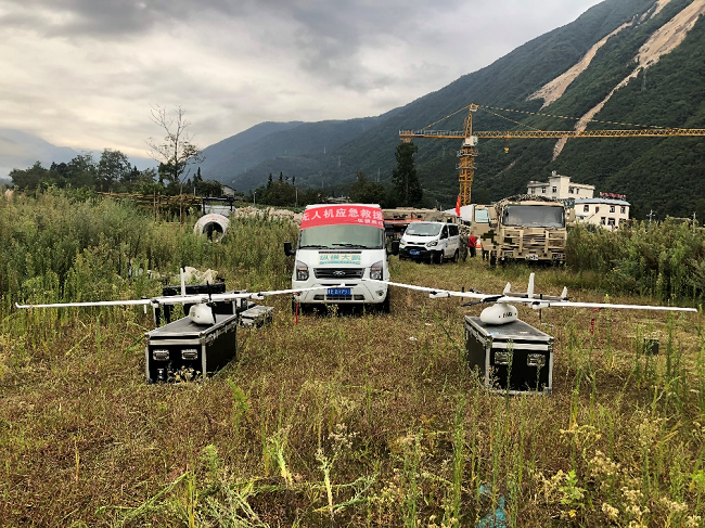
Time is life, and every second is more hope. After the earthquake, the Sichuan Provincial Emergency Management Department quickly coordinated large-scale high-altitude full netcom UAV and pterosaur large-scale fixed-wing emergency communication UAV.D2000 unmanned flight platform and other scientific and technological products are put into "actual combat", which provides first-hand information support for the "first-time judgment, first-time decision-making and first-time rescue" of the front and rear headquarters, effectively ensuring accurate command and decision-making, scientific cooperation and efficient rescue.
"Dear comrades-in-arms, Sichuan Tengdun’s emergency drone is carrying out communication support tasks in this area. Please call or send text messages in time to wish you peace!"
After the earthquake, the Sichuan Provincial Communications Administration and the Emergency Management Department immediately launched the second-level response and emergency dispatch of emergency communications support."Large-scale high-altitude network-wide emergency communication drone" went to the disaster-stricken area. While providing communication network services for the people in the disaster areas, many people were able to contact their families to report their safety, which eased the tense atmosphere in the disaster areas and set up a "lifeline" for the people in the disaster areas!
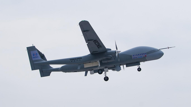
At 17: 00 on September 5, the Tengdun double-tailed scorpion drone mounted the photoelectric reconnaissance pod and the airborne base station equipment took off at the airport. After 1 hour and 40 minutes, the drone flew over the epicenter area, started a wide-area inspection of the disaster and implemented the public communication coverage task.
At around 20: 00 on September 5, the emergency rescue and disaster relief command and the mobile phone communication of the affected people resumed one after another, and the local residents successively received "users in the disaster area of [Sichuan Communications Administration], and your mobile phone has been connected to the communication network through the high-altitude base station carried by Sichuan Tengdun UAV, providing you with real-time voice and SMS services".
It is reported that the cumulative access users in this operation.More than 6,000 households sent tens of thousands of prompt messages, connected more than 2,000 telephones, and provided 5.34GB of data traffic for emergency rescue and disaster relief commanders and affected people.watch from a height or distanceCommunication guarantee service.
Under the coordination of the emergency management department, pterosaurThe -2H emergency rescue drone was equipped with the air and space emergency communication system of China Mobile (Chengdu) Industrial Research Institute to fly to the disaster area urgently.
At 18:30 on September 5, the plane arrived in Moxi Town, the epicenter, and immediately carried out reconnaissance and emergency communication support tasks. Then he flew to Huanggangping, Ya ‘an, and successfully resumed the communication between Ya ‘an Command Center and Wanggangping Township, and successively completed the tasks of communication guarantee, disaster reconnaissance, 370M cluster and providing mobile voice data. According to preliminary statistics, this take-off accumulated more than 1,000 users, generated total traffic of 235.5MB, provided VOLTE voice for more than 600 minutes, and successfully sent more than 700 short messages.
After a comprehensive inspection of the drone by the on-site emergency support team,At 10: 01 on September 6th, the pterosaur -2H UAV flew to the disaster area again to detect the dammed lake, collapsed houses, collapsed tunnels, broken water pipes and landslides, and completed the tasks of communication guarantee and real-time transmission of audio and video information in Wanggangping Township, Xinqiao Village and Xingfu Village, realizing the real-time transmission of disaster investigation to the command center of the Emergency Management Department, which provided strong support for the scientific and timely deployment of earthquake relief work.
At 6: 30 on September 7th, pterosaur -2H UAV III went to the disaster area, and continued to carry out disaster reconnaissance and regional emergency communication support tasks such as Jinzhulin and Aiguo Village, to ensure smooth communication between the ground rescue forces and fully promote the rescue work.
Every minute counts for investigation and detection.
Accurate command and dispatch needs timely and effective information support.
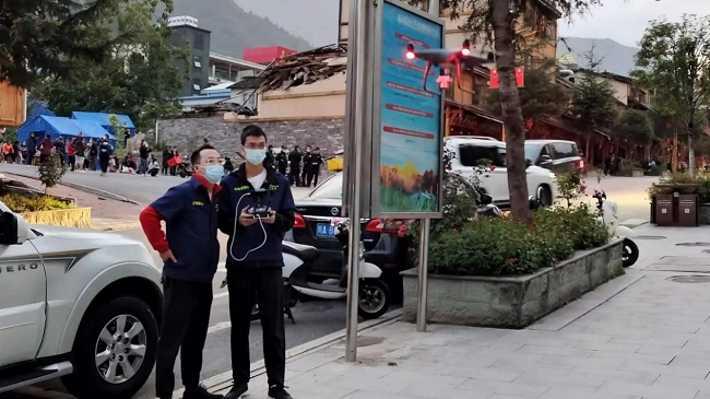
According to the unified arrangement of the Emergency Management Department, Sichuan Academy of Security Sciences immediately launched an emergency response.In 8 minutes, the "Brief Report on Rapid Assessment of the" 9.5 "Luding County M6.8 Earthquake in Ganzi Prefecture, Sichuan Province" was generated and quickly reported to the provincial earthquake relief headquarters to provide auxiliary support for the headquarters to accurately formulate rescue strategies. Twenty minutes after the earthquake, the first batch of front working groups (one car and five people) rushed to the scene with D2000 unmanned flight platform and D1000 unmanned aircraft.
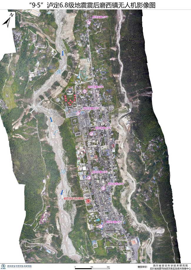
At 19: 36 on September 5, the front working group arrived at the front headquarters of earthquake relief in Moxi Town, Luding County, and then used D1000 UAV to complete the VR panoramic image production of Moxi Town, and quickly transmitted the actual situation of the disaster to the rear command and decision, realizing the synchronization of on-site disaster analysis and rescue force scheduling.
At 11: 00 on September 6, the front-line working group completed the post-disaster UAV image map of Moxi Town, and at 15: 00, the VR panoramic image of the road interruption site in Moxi Town was completed, and the post-disaster UAV image map of Detuo Town was completed.
While doing a good job of drone mapping ahead, Sichuan Academy of Safety Technology continued to carry out disaster relief information statistics and monitoring of river water level changes in the earthquake zone, and accumulated ""9.5" Luding M6.8 Earthquake Flood and Drought Disaster Rapid Assessment Briefing No.3 provides strong support for scientific decision-making of earthquake relief.
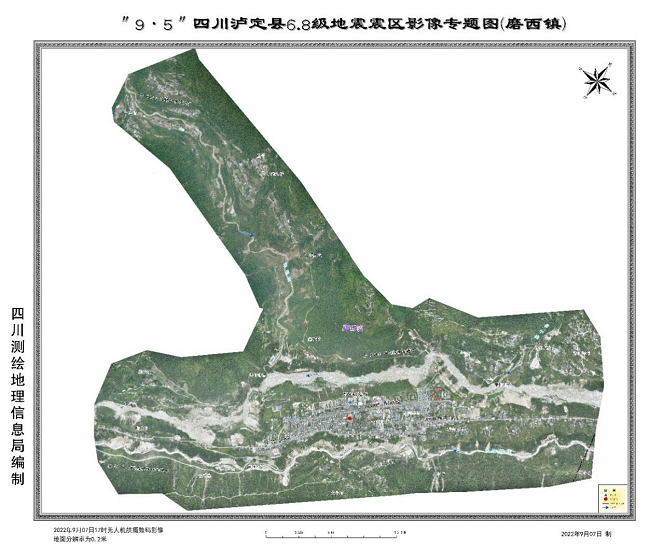
Complete the digital orthophoto map of the epicenter,
Obtaining high-resolution visible light and radar images, fully grasping the changes of topography and providing technical support in time are powerful guarantees for commanding and rescuing.
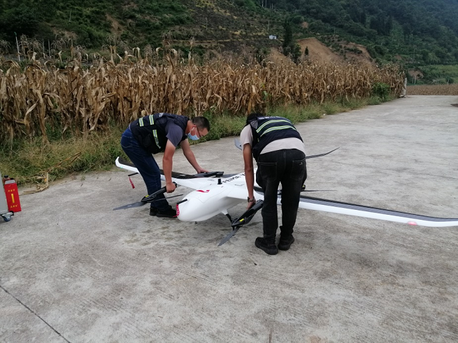
After the earthquake, the Sichuan Provincial Emergency Management Department quickly coordinated the Sichuan Surveying and Mapping Geographic Information Bureau, started the cooperation mechanism in time, and immediately dispatched it.Thirteen emergency forces are divided into front and rear working groups to carry out surveying and mapping tasks.
On the afternoon of September 5th, the emergency surveying and mapping intelligent service team arrived at the command center of the emergency management office to participate in the actual operation of earthquake relief around the clock. Relying on the self-developed 3D geographic information emergency service platform, it summarized the basic geographic spatial information before and after the disaster, as well as the thematic information such as earthquake disaster and rescue force distribution, and continuously analyzed and processed the data in real time to form a preliminary image map of the topography, important target features and hidden dangers of geological disasters in the earthquake-stricken areas. At the same time, the advantages of the mapping system were brought into play, and 12 maps for emergency command of earthquake relief and 12 image maps of Luding County and towns were completed 2 hours after the earthquake, which provided information guarantee for the headquarters to effectively fight against the earthquake and verify the disaster situation in the first time.
On September 6th, Rainbow -4 UAV took off from Zigong Fengming Airport to obtain 100 square kilometers of sar data in the disaster area. It is reported that this operation took advantage of the long-range reconnaissance of fixed-wing UAV and the flexibility of low-altitude UAV in AVIC, and successfully obtained the first batch of high-resolution visible light and radar images after the earthquake, which provided technical support for command and rescue, and realized the three-dimensional and visible reflection of the disaster.
On the morning of September 7th, in order to further obtain the real-time disaster data, the Bureau of Surveying and Mapping dispatched two unmanned aerial vehicles (UAV) teams consisting of Pegasus V100 from Zigong and Chengdu to Luding County, and used them in time to obtain 18 square kilometers of orthophoto images. Subsequently, the UAV team in front and the technical force of the rear emergency service platform worked together to produce the thematic map of Detuo Township and the thematic map of Moxi Town, which provided first-hand information for the headquarters to carry out disaster judgment, emergency command and post-earthquake rescue.
On September 8, the drone took off again in Wanggangping Township, Shimian County to obtain 40 square kilometers of orthophoto images along Wanggangping Township to Xinmin Township and Longtoushi Dam.
At the same time, from Sichuan ProvinceThe "9.5" Luding earthquake relief provincial, city (state) and county front-line joint command vertical and horizontal Dapeng CW-15 mapping UAV system completed the digital orthophoto map of Moxi town in Luding epicenter.
"Among them, the camera mainly shoots high-definition digital images of the disaster-stricken areas, which can quickly splice orthophoto maps and keep abreast of the overall situation." Relevant personnel of the earthquake relief headquarters told reporters that it is reported that at 7: 00 am on September 6, according to the unified arrangement of the command department, CW-15 mapped the UAV system, flew for 60 minutes and took more than 300 photos, successfully completing the 1:1000 orthophoto map collection of 7 square kilometers in the designated area. Subsequently, at 7: 30 the next day, CW-15 mapping UAV system and CW-15 monitoring UAV system were used again to fly and carry out operations, and the digital orthophoto and video real-time data of Moxi Town in Luding County were obtained to help Luding earthquake rescue.